 |
| At Whimsical's helm |
Hello faithful followers. As of this writing, we are (with respects to Jerry
Reed's classic road trip anthem) eastbound and down on my epic journey, aboard
Sailing Vessel Whimsical! Here's a recap
of the last few days:
Our original plan was to head out into the Gulf of Mexico and make it all the way around the Mississippi River Delta, then turn north and hug the Mississippi coastline. I spent a good chunk of time studying maps and wind forecasts, and plotted a course that would - hopefully - take advantage of wind shifts and get us to the above said destination in the most expeditious possible way. Well as they say, we sailors must always remain flexible and open to change. Plans and schemes and dreams are made to be … adjusted.
Paul and I successfully left Kemah early Thursday morning and made our way out into the Gulf. Now, Whimsical is indeed a fine sailing vessel. But after a few hours in the Gulf, we had to logically conclude that simply being a fine vessel does not necessarily mean that your boat is a BLUEWATER boat. Whimsical was struggling to sail eastward against easterly winds, bashing HARD into the waves. Nearly every wave was crashing over the bow, spraying its wide-open cockpit and everything therein with seawater. The rough seas made it impossible to make reasonable forward progress - not to mention being as uncomfortable as hell.
We had to come up with a Plan B. The best option was to head inland and use the good ole' reliable Intracoastal Waterway (ICW), that safe and secure route that stretches all the way along the Gulf and Atlantic coasts. It would be slower than sailing the Gulf, because: 1) It did not run in a straight line, 2) you really could not safely transverse it at night, and 3) there were locks and drawbridges.
The closest place to get into the ICW was via Sabine Pass, south of Port Arthur, Texas.
Thereafter followed sixty grueling miles of fighting that monstrous oceanic beast. There were many moments in that wet, thrashing, miserable, sleepless night when I repeatedly asked myself: why oh why oh why did I volunteer to do this?!? But we finally made it to Sabine by mid-morning on Friday. Calm waters at last.
For the rest of the day, Whimsical
followed Dragonfly's now-familiar path, up the Sabine River, hugging the city
of Port Arthur, clipping the north end of Sabine Lake, and even passing right
by Joan and my Favorite Anchorage In The Whole Wide World: Shell Island, right where the river empties
into the lake.
 |
| Going under the Ellender Bridge. Whimsical's mast did NOT require an opening! |
But as soon as the anchor was down, there was a new problem: BUGS. Millions of them! Vicious mosquitos and other little nasties were all over us in no time. We had a tent-like mosquito net on board, for which we quickly deployed in the open cockpit. But - we had no insect repellant. That night, even under the net and with my bedsheet pulled over my head, it was yet another sleepless struggle, constantly swatting and scratching at the aggravating pests. Oh and if that isn't enough, we were even awoken sometime in the night by the sound of cows mooing!
 |
| ICW from Calcasieu to Sweet Lake |
 |
| Calcasieu Lock |
Right past the Calcasieu Ship Channel are the Calcasieu Locks. These are salt water intrusion locks, whose purpose is to keep the fresh water on the other side … fresh. The locks are very long and narrow. We had to wait our turn, behind two other tug-and-barge tows, one going each way. Ah, delays. Once finally thru, it was onward thru the marshes of southern Louisiana!
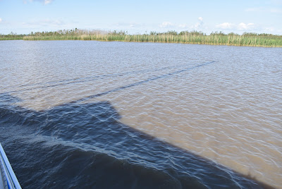
On the fresh water side, the ICW pretty much looked pretty much the same as the other side, with a few notable exceptions. The first big difference was the striking remoteness of the area. Aside from an occasional water craft, there was absolutely no sign of humanity for miles and miles. Another difference was that the water was, somewhat counter-intuitively, muddier. Like, chocolate milk brown.
 |
| Fresh water part of ICW. It was wide, muddy, and lined with large trees. Looked more like a river. |
The waterway was also, in some areas, extremely WIDE. After the bend near Sweet Lake, the channel opened up to, I estimate, well over 200 yards wide, possibly 300. And we pretty much had the whole dang thing to ourselves. I suggested to Paul that, with all this room, maybe we could raise up the sails, turn off the engine, and TACK upwind toward our destination to the east. Paul was not too keen on the idea.
ICW from Sweet Lake to Mermentau River Grand Lake. Pretty, except for the green scum.
The next landmark was the
Mermentau River. The ICW crosses it
right at its mouth, where it empties into Grand Lake. Very wide open and picturesque - if you
disregard all the green slime floating on the surface.
Now to find an anchorage - before the sun goes down. Hopefully with fewer bugs! Well, we were able to procure a can of "Off" back at Calcasieu Point.
More travel adventures in the
coming days are guaranteed. Stay tuned!
 |
| Whimsical's shadow on the water |


David, Jeremy has been sharing your blogs with us. What a great way to track your adventures and to let everyone know what you’re up to. Stay safe out there and enjoy every moment...and for Pete’s sake get some extra cans of bug spray!! You can never have enough of that stuff, lol. They even make sunscreen with bug spray in it, win win.
ReplyDeleteRegards,
Jason Font